Distance
Elevation Gain
Trailhead
Location
Water Xing
Trail Description
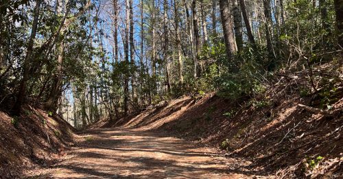
West Prong Trail is an easy to moderate 2.7 mile out and back trail starting near the Great Smoky Mountains Institute at Tremont and ending at an intersection with Bote Mountain Trail.
To reach the trailhead, head toward Cades Cove from the Townsend Wye and almost immediately take a left at the sign indicating Tremont Road. It's about two miles to reach the institute from here. Just before the parking lot for the book store, you'll see a sign on the right indicating parking for West Prong Trail. Turn right up the short road to reach a gravel parking lot. The trailhead is accessible from here, just to the right of the pump house.
The trail starts to climb the flanks of Fodderstack Mountain. In the 2.7 miles one way you will ascend for just over a mile, go back down to reach backcountry campsite #18 (with a large group camp and at least four smaller camps) around the 2 mile marker, and then ascend one final time for the last 0.7 of a mile before reaching the junction with Bote Mountain Trail.
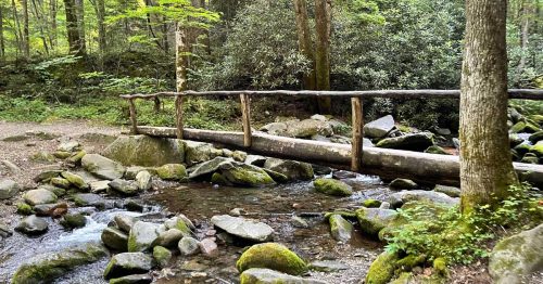
There is a maintained cemetery accessible from a spur trail almost immediately to the right after the West Prong Trail trailhead. Another spur trail to the same cemetery shows up around the 0.3 mile marker at a fork in the trail; continue to the left for West Prong. There's an easy rock hop over a side creek just before the backcountry campsite #18. The campsite sprawls over a large area. To continue on West Prong Trail, head over the sturdy foot bridge and slightly to the right under a sweet gum tree (you'll see sweet gum balls all over the ground). The trail narrows back uphill and curves to the left.
Overall West Prong Trail is a nice hike with enough challenge to get your blood pumping, but not one of the most difficult trails in this area. It's pleasant at most times of year and offers plenty of solitude, history, eastern hemlock and mountain laurel.
[+ Read More]West Prong Trail Elevation Profile

Trail Difficulty Scales Explained
Elevation Grade
4%
Fairly Flat
Paul Petzoldt Scale
3.8
Easy
5
10
15
Shenandoah Scale
54
Moderate
50
100
150
Photo Gallery (8)


- Abrams Falls Trail (4.2 mi)
- Ace Gap Trail (5.4 mi)
- Albright Grove Loop Trail (0.7 mi)
- Alum Cave Trail (Mt. LeConte) (5 mi)
- Andrews Bald via Forney Ridge Trail (1.8 mi)
- Anthony Creek Trail (3.5 mi)
- Appalachian Trail Smoky Mountains Segment (71.7 mi)
- Baskins Creek Trail (2.7 mi)
- Baxter Creek Trail (Mt. Sterling) (6.2 mi)
- Big Creek Trail (Mouse Creek Falls, Midnight Hole) (5.8 mi)
- Bote Mountain Trail (6.6 mi)
- Boulevard Trail (Mt. LeConte) (5.4 mi)
- Bradley Fork Trail (7.3 mi)
- Brushy Mountain Trail (Mt. LeConte) (4.9 mi)
- Bullhead Trail (Mt. LeConte) (5.9 mi)
- Cataract Falls (Fighting Creek, Cove Mountain Trail) (0.5 mi)
- Charlies Bunion via Appalachian Trail (4.2 mi)
- Charlies Bunion via Kephart Prong Loop (14.2 mi)
- Chestnut Branch Trail (2.1 mi)
- Chestnut Top Trail (4.3 mi)
- Chimney Tops Trail (2 mi)
- Cooper Road Trail (10.5 mi)
- Cove Mountain Trail (8.5 mi)
- Crooked Arm Ridge Trail (2.2 mi)
- Cucumber Gap Trail (2.4 mi)
- Curry Mountain Trail (3.3 mi)
- Dry Sluice Gap Trail (4.2 mi)
- Eagle Creek Trail (8.9 mi)
- Elkmont Nature Trail (0.8 mi)
- Finley Cane Trail (2.8 mi)
- Forney Ridge Trail (5.4 mi)
- Gabes Mountain Trail (Hen Wallow Falls) (6.6 mi)
- Gatlinburg Trail (1.9 mi)
- Goldmine Trail (0.8 mi)
- Grapeyard Ridge Trail (7.6 mi)
- Gregory Bald Trail (Gregory Bald) (7.3 mi)
- Gregory Ridge Trail (Gregory Bald) (5 mi)
- Grotto Falls (Trillium Gap Trail) (1.4 mi)
- Hannah Mountain Trail (9.5 mi)
- Hatcher Mountain Trail (2.6 mi)
- Huskey Gap Trail (4.1 mi)
- Indian Grave Gap Trail (3.7 mi)
- Jakes Creek Trail (3.7 mi)
- Kephart Prong Trail (2 mi)
- Kuwohi Trail (formerly Clingman’s Dome) (0.6 mi)
- Laurel Falls Trail (4 mi)
- Lead Cove Trail (1.8 mi)
- Little Bottoms Trail (2.3 mi)
- Little Brier Gap Trail (Walker Sisters Cabin) (1.4 mi)
- Little Greenbrier Trail (4.3 mi)
- Little River Trail (6.1 mi)
- Low Gap Trail (5.4 mi)
- Lower Mt. Cammerer Trail (7.4 mi)
- Lumber Ridge Trail (4.1 mi)
- Lynn Camp Prong Trail (3.7 mi)
- Maddron Bald Trail (Albright Grove) (7.3 mi)
- Meigs Creek Trail (3.5 mi)
- Meigs Mountain Trail (6 mi)
- Metcalf Bottoms Trail (0.7 mi)
- Middle Prong Trail (Indian Flat Falls) (4.1 mi)
- Miry Ridge Trail (5 mi)
- Mt. Cammerer Trail via Low Gap + AT (5.6 mi)
- Mt. Sterling Ridge Trail (5.3 mi)
- Newfound Gap to Clingmans Dome (7.9 mi)
- Noland Creek Trail (9.2 mi)
- Old Settlers Trail (15.8 mi)
- Old Sugarlands Trail (3.9 mi)
- Panther Creek Trail (2.3 mi)
- Porters Creek Trail (Fern Branch Falls) (3.7 mi)
- Rabbit Creek Trail (7.8 mi)
- Rainbow Falls Trail (Mt. LeConte) (6.6 mi)
- Ramsey Cascades Trail (4 mi)
- Rich Mountain Loop (8.7 mi)
- Roundtop Trail (7.5 mi)
- Russell Field Trail (3.5 mi)
- Schoolhouse Gap Trail (Whiteoak Sink) (2.1 mi)
- Shuckstack Fire Tower from Fontana Dam (4.6 mi)
- Spence/Russell Field Loop (13.7 mi)
- Spruce Flats Falls Trail (Buckeye) (1 mi)
- Sugarland Mountain Trail (11.9 mi)
- Swallow Fork Trail (4 mi)
- Sweat Heifer Creek Trail (3.7 mi)
- The Jump Off (Boulevard Trail) (3.3 mi)
- Thunderhead Mountain (Rocky Top) (6.1 mi)
- Trillium Gap Trail (Grotto Falls, Mt. LeConte) (8.9 mi)
- Turkeypen Ridge Trail (3.6 mi)
- Twentymile Loop Trail (2.9 mi)
- Twentymile Trail (5 mi)
- West Prong Trail (2.7 mi)
- Whiteoak Sink via Schoolhouse Gap Trail (2.3 mi)
The above list of hiking trails in the Smokies is incomplete and constantly being updated. If you have information or photos you would like to contribute, please contact [email protected].
Featured Posts
Sep 14, 2026

Almost Autumn Giveaway
The Smokies are so close to crispy leaves and bright autumn colors, and we're ready to celebrate by giving awa...
Read This PostAug 2, 2026

Celebrate Fall at Anakeesta’s Bear-Varian Festival
Fall in Gatlinburg brings crisp mountain air, beautiful leaves, and endless ways to enjoy the season. The Smok...
Read This PostMay 4, 2026
Rainforest Adventures Discovery Zoo: A Must-Visit for Families in Sevierville
If you're looking for a fun, hands-on attraction that's perfect for families in the Smokies, Rainforest Advent...
Read This Post